
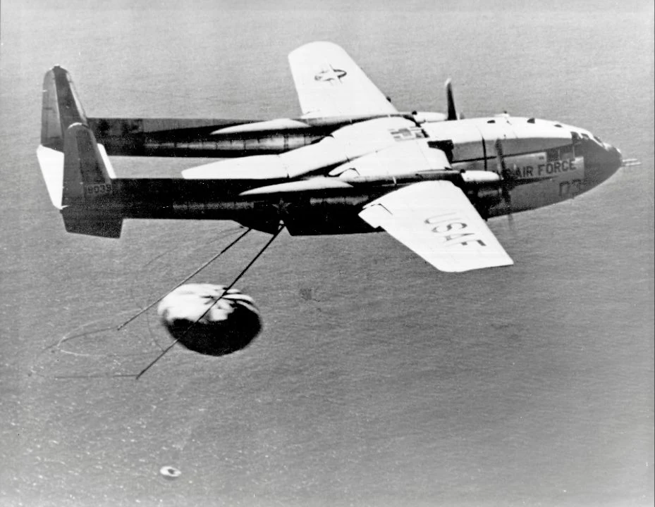
A CORONA satellite could photograph a Soviet airfield from orbit, yet the exposed film was still beyond anyone’s reach. To turn the photograph into useful evidence, the United States had to bring a small capsule through the atmosphere, find it over the Pacific and retrieve its cargo.
The airplane catch was the most striking part of that journey. The complete story connects a camera, a reentry vehicle and a laboratory—and explains why seeing more territory did not mean seeing everything.
Why send film home from a satellite?#
CORONA was a joint CIA–Air Force reconnaissance program concealed publicly behind the Discoverer name. Its cameras recorded photographs on film. The information in those images returned as a physical object, rather than as a stream of digital pictures.
The satellite loaded exposed film into a recovery capsule. Recovering that capsule avoided having to return the entire orbiting camera system. The capsule was a delivery container for the intelligence; it was only one part of the spacecraft.
The cameras also changed over the program’s life. USGS records distinguish early single-camera systems from later CORONA versions with two panoramic cameras, looking forward and backward. There was no single camera specification that describes every CORONA mission.
How did the capsule leave orbit without destroying the film?#
Separation alone would leave the capsule moving along an orbit. On Discoverer XIV, retrorockets attached to the return vehicle slowed it after ejection, committing it to atmospheric reentry. “Retro” describes thrust that opposes its motion: the capsule needed to lose orbital speed before air could slow it further.
A heat shield protected the payload during the high-speed passage through the atmosphere. The parachute belonged to a later stage, after the dangerous reentry phase; it could not substitute for that thermal protection.
The diagram separates the return into functions: leave orbit, survive reentry, descend and retrieve. Its arrows show the order of operations, not a measured flight path or the relative heights of the aircraft and satellite.

Image unavailable.
Five steps connect exposed film to interpreted evidence: store, reenter, descend, recover, then process and interpret; an ocean fallback is noted.
What did the airplane actually catch?#
It caught the parachute with recovery gear trailing behind the aircraft. It did not scoop up a bare capsule or meet the spacecraft in orbit. A winch then brought the recovered load aboard.
Discoverer XIV launched on August 18, 1960. The following day, a modified C-119 recovered its capsule over the Pacific. The Air Force museum’s account places the interception southwest of Honolulu and says the crew succeeded on its third pass. Those extra passes matter: even after a successful return, the delivery still depended on locating and engaging a moving target.
The catch also accelerated the falling package toward the aircraft. A participant’s recovery account describes allowing line to pay out under controlled braking to limit the load before reeling it in. Catching and winching were connected stages, rather than a single rigid tug on the parachute.
What happened if the aircraft missed?#
The ocean offered another recovery route. Discoverer XIII’s capsule reached the Pacific and was retrieved by a Navy team on August 11, 1960. This was an important recovery achievement, but it was a diagnostic mission rather than the first successful return of reconnaissance photography.
That distinction resolves a confusing pair of “firsts.” XIII demonstrated recovery from orbit; XIV returned the photographic payload and achieved the midair catch a week later. A recovered test capsule and recovered useful imagery were different milestones.
Ocean recovery also had a security deadline. Recovery engineer Edward Miller describes a dissolving saltwater plug intended to make an unretrieved capsule sink after about a day. It was a safeguard against someone else collecting the cargo, at the cost of losing it if the recovery force could not arrive in time.
Sources: [2]
When did recovered film become usable intelligence?#
First it needed processing. Photo interpreter David Doyle recalled that the August 1960 film went to Eastman Kodak in New York before reaching the photographic interpretation organization. Analysts then had to identify features, place them geographically and compare them with existing knowledge.
USGS lists the first successful KH-1 system’s best ground resolution as 40 feet, about 12 metres. That is a measure of ground detail, not the width of the photograph or a guarantee that every object that size could be identified. Grain, cloud and the appearance of the target affected what an interpreter could conclude.
An airfield occupies a large, recognizable arrangement of ground. A small piece of equipment demands finer detail. This is why broad coverage could answer questions about the distribution of installations while leaving questions about their contents open. Enlargement could make a photograph easier to inspect; it could not manufacture missing detail.
Film also imposed a delay: the exposure, recovery and processing happened before interpretation. These were records of earlier overflights, rather than a live view of events below.
How could photographs reduce a perceived threat?#
The CIA’s history credits CORONA imagery with helping overturn inflated expectations of Soviet bomber and missile strength. A reconnaissance system could therefore challenge an alarming estimate as well as uncover a new installation.
That conclusion required more than failing to spot a missile in one picture. An absence becomes persuasive only in relation to what was covered, what was visible and what the camera could resolve. Clouds or an unphotographed area leave uncertainty. The historical achievement was a stronger evidential basis for estimates, rather than proof that every threat had been located.
The CIA also describes satellite photography’s importance to arms-control verification: interpreters could monitor observable changes in major weapons installations. That is a practical advantage of repeatable observation. It does not establish a government’s intentions or guarantee compliance with every obligation.
For CORONA, every such judgment depended on a long chain working. The airplane delivered film. Processing delivered visible images. Interpretation connected those images to questions decision-makers could actually answer.
Keep exploring
Sources & further reading
Follow the original research, records, and explanations behind this story.
- CORONA: America's First Imaging Satellite Program Central Intelligence Agency
Program identity, early failures, strategic estimates and verification. Museum narrative read; embedded media not played.
- Intelligence Revolution 1960: Retrieving the Corona Imagery That Helped Win the Cold War National Reconnaissance Office, Center for the Study of National Reconnaissance
Participant accounts: recovery sequence pp.41–47; load control p.60; processing and interpretation pp.65–68. Retrospective recollections, not independently reconciled engineering specifications.
- USGS EROS Archive - Declassified Data - Declassified Satellite Imagery - 1 U.S. Geological Survey
Film return, camera generations and best ground resolution: KH-1 40 ft. Current scanning prices omitted.
- Discoverer XIV National Museum of the United States Air Force
Launch, retro firing, parachute interception on third pass and winch recovery.
Follow the thread