

People donated toward drones. The money ultimately helped Ukraine obtain radar imaging from spacecraft already circling Earth. The practical question is what that agreement delivered—and what a radar image can actually tell its reader.
The answer involves three different things: access to observations, operation of a spacecraft, and interpretation of its measurements. Keeping them separate makes the “People’s Satellite” easier to understand.
What did the August 2022 agreement provide?#
On 18 August 2022, ICEYE announced a contract with the Serhiy Prytula Charity Foundation. It covered the full capabilities of one satellite already in orbit for Ukraine’s use over the region, plus imagery access from ICEYE’s wider radar satellite constellation. ICEYE would continue operating the satellite.
That arrangement gave Ukraine access without waiting for a new launch. It also means that “buying a satellite” is incomplete shorthand: the public announcement describes capabilities and data access while explicitly retaining company operation. It does not establish that donors could steer the spacecraft themselves. The announcement is evidence of the agreement’s stated scope, rather than a substitute for the contract text itself.
Sources: [1]
Why was money raised for drones used for space imagery?#
According to the Foundation’s project account, the funds came from the June 2022 People’s Bayraktar campaign. After Baykar supplied three drones free of charge, the Foundation used the saved funds for the satellite deal.
The connection is therefore financial and organizational: donations supported an agreement for an existing commercial observation capability. The change of purchase did not require the donors to build a spacecraft or arrange its launch.
How can radar make an image through clouds?#
Radar supplies its own illumination. An antenna transmits microwave pulses toward the ground and receives the small share of their energy scattered back. These returning echoes carry information about distance and the surface’s response. Clouds need not block these wavelengths as they block a visible-light view; sunlight is unnecessary.
“Synthetic aperture” explains how a relatively small antenna produces useful detail. As the spacecraft moves, it measures a ground patch from successive positions. Processing combines those echoes to achieve the effect of a longer antenna along the flight direction. The image is computed from measurements collected during motion.
This is active radio sensing. Its brightness records returned radar energy, rather than visible color or a map of emitted heat.

Image unavailable.
Three successive radar positions send pulses toward the same ground patch; returning echoes are combined in processing.
What does a bright patch really mean?#
A bright patch means a strong return toward the instrument. Its cause still needs interpretation. Roughness, water content and viewing angle can change the response, so brightness alone does not identify an object.
For example, calm water often looks dark because its smooth surface reflects much of the signal away from the satellite. Wind can roughen that same water and increase the return. Buildings can be very bright when their geometry sends energy back toward the sensor. Slopes can distort apparent shapes or create radar shadows.
A conceptual coastline under clouds is a useful example: radar may reveal the boundary between land and water while an optical view is obscured. It does not follow that every dark patch is water, or that radar sees through every roof. Context and skilled analysis remain essential.
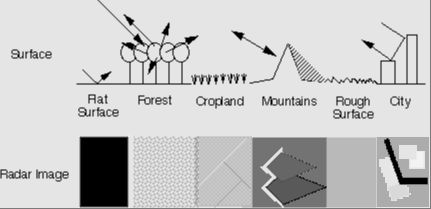
Image unavailable.
Historical JPL illustration compares radar scattering by flat ground, forest, cropland, mountains, rough ground and a city with corresponding schematic image patterns.
Does frequent imaging mean a continuous live view?#
No. ICEYE’s announcement promised a high revisit frequency through constellation access. A revisit is another opportunity to observe a location; it is different from an uninterrupted view.
Measurements must be acquired, turned into an image and interpreted. The public announcement does not specify a universal interval or delivery delay, so no numerical promise is made here. Additional satellites can provide more observation opportunities, but “all weather” describes a sensing advantage rather than continuous live video of every place.
What changed about access to space?#
This case shows a commercial route from fundraising to satellite observations: a foundation arranged access, a company operated the spacecraft, and users received measurements to interpret. Launching a national spacecraft was no longer the only route to obtaining this kind of information.
That is a conclusion about the 2022 arrangement. It does not establish today’s access rules, prove a particular battlefield outcome, or show that everyone can purchase the same service. The useful distinction is between having hardware overhead and being able to obtain—and understand—the information it gathers.
Keep exploring
Sources & further reading
Follow the original research, records, and explanations behind this story.
- ICEYE Signs Contract to Provide Government of Ukraine with Access to Its SAR Satellite Constellation ICEYE
18 August 2022 announcement: existing orbiting satellite capabilities, constellation imagery and ICEYE operation; not the full contract.
- People’s Satellite Serhiy Prytula Charity Foundation
Fundraiser origin and announced agreement. Later military outcome claims are outside this article.
- What is Imaging Radar? NASA Jet Propulsion Laboratory; Tony Freeman
Pulse/echo imaging, synthetic aperture, day/night and cloud capability. Historical technical explainer; its instrument parameters are not ICEYE specifications.
- Get to Know SAR – Overview NASA
General SAR focusing and interpretation: roughness, moisture, viewing geometry, water and structures. No NISAR specifications are assigned to ICEYE.
Follow the thread