
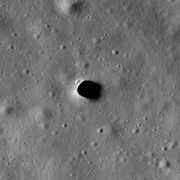
Spacecraft have photographed the walls and parts of the floor of the Marius Hills pit on the Moon. Radar and gravity studies have also found signals consistent with buried empty space in the surrounding volcanic terrain.
A visible pit, an overhanging roof and a possible long lava tube are different discoveries. The observations do not yet provide a dependable map of the cave that might lie beyond the opening.
Where is the Marius Hills pit, and what is it?#
The Marius Hills pit is a steep opening in an ancient volcanic region on the Moon’s near side. JAXA places it near 14.1° north, 303.3° east, equivalent to about 56.7° west. It lies within a winding channel called a sinuous rille, among terrain shaped by past lava flows.
Its setting makes a collapsed lava-tube roof a plausible explanation. A skylight is an opening through the roof of an underground space; it does not tell us how much of that space survives. The visible hole could connect to a substantial passage, or the accessible void could be much more limited.
An impact crater forms when a projectile excavates material. A collapse pit forms when support beneath a roof disappears or the roof fails. Those mechanisms can interact: the LROC team notes that an impact might have punched through an existing lava-tube roof here. The volcanic setting supports the skylight interpretation, while the exact event that opened this particular hole remains an interpretation.
What did Kaguya discover, and what did LRO add?#
Japan’s SELENE spacecraft, also called Kaguya, first revealed the pit in camera observations reported in 2009. Its Terrain Camera and Multiband Imager observed the opening under different sunlight, at resolutions reaching about six metres per pixel. A pixel is one picture element: at that scale, features several metres across occupy only a small part of the image.
NASA’s Lunar Reconnaissance Orbiter subsequently supplied much finer views. The LROC team’s March 2010 presentation used a Narrow Angle Camera image at about half a metre per pixel. It showed details around the rim that the earlier pictures could not resolve as clearly, including small boulders and a small crater on the northwestern edge.
Changing the Sun’s position is especially valuable. Low sunlight leaves much of the opening dark; a higher Sun lights more of the floor. In the three-view sequence published by LROC in September 2010, the high-Sun central image illuminated roughly three-quarters of the floor. The black patch in another exposure therefore includes shadow over a real surface. Its darkness alone cannot measure the extent of an unseen tunnel.
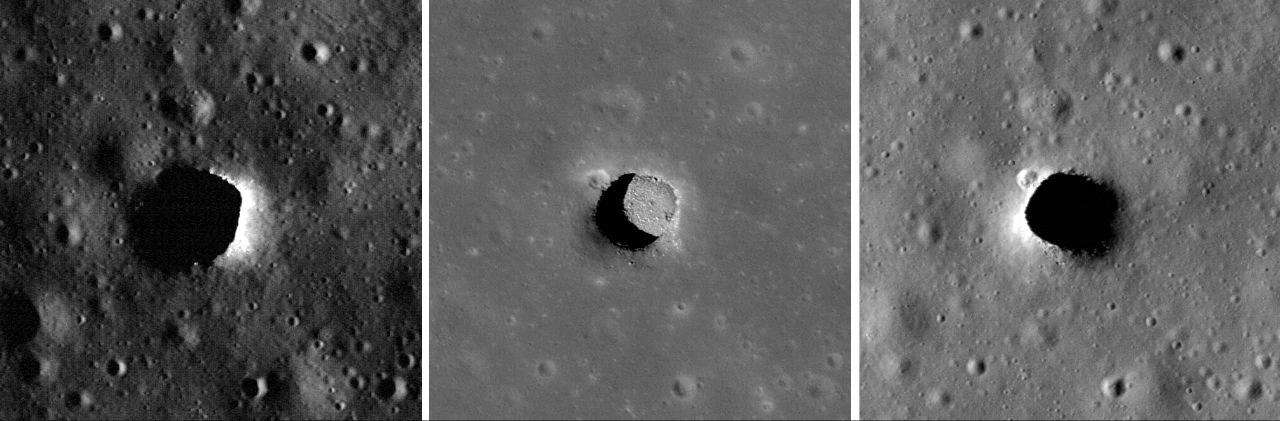
Image unavailable.
Three orbital views of Marius Hills pit; the middle high-Sun view exposes much of the floor while the outer views are mostly shadowed.
How big is the opening?#
The LROC team’s revised description gives the pit as approximately 58 by 49 metres across and 40 metres deep. These are dimensions of the observed pit, rather than a measurement of a connected underground chamber. Forty metres is the approximate vertical descent being discussed, not the thickness of every part of a possible roof.
The numbers have changed as the images improved. The original March 2010 page described a roughly 65-metre diameter; a September 2010 account gave 65 by 90 metres and a depth of 34 metres. The named-pit page carries an explicit 2017 update saying that measurements from several later images with higher Sun elevations revised the dimensions to 58 by 49 metres and 40 metres deep.
Sunlit walls and shadow boundaries constrain geometry, but they do not all mark the same boundary. A sloping approach, the sharp opening and a partly hidden floor are different surfaces. The updated page does not provide a full survey drawing that reconciles each older boundary. The revised dimensions describe the observed pit; the extent of a connected cavern remains unmeasured.
How could a river of lava leave a hollow tube?#
A lava tube can form when a stream of molten rock gains a solid roof while lava continues flowing underneath. Cooling can build a crust across an open lava channel; lava can also travel beneath an already cooled field. If the liquid drains away, a hollow passage can remain.
A later roof collapse exposes that passage from above. Other stretches may stay covered, collapse into a winding depression or become obstructed. That is why the rille around Marius Hills is a useful geological clue: winding channels can record open lava flows, roofed flows and later collapse.
The same history also explains the scientific interest. Sheltered rock surfaces may preserve volcanic textures that exposed surfaces lose through impacts and space weathering. Reaching them could reveal how the lava moved and cooled. Their preservation and accessibility would still need examination at the site.
Do the pictures show a cave continuing underground?#
The orbital evidence supports space beneath overhanging rock, but it does not trace a long connected tunnel. JAXA’s 2017 account reports that later downward-looking and oblique LRO observations of the large lunar holes, including Marius Hills, showed floors continuing at least several metres eastward and westward beneath the ceiling. The same account explicitly says that whether these spaces are lava tubes remains unknown.
An oblique image looks sideways as well as down. That can reveal floor beyond the edge that a straight overhead view hides. It establishes a local overhang and sheltered space where the geometry is visible. Beyond the illuminated and exposed surfaces, the camera loses its view.
This distinction matters when drawings show a huge passage behind a small entrance. Such a drawing can illustrate a geological hypothesis. It cannot supply the missing observations of the roof, floor, branches or obstructions farther inside.
What do radar and gravity suggest about a larger tube?#
The geophysical evidence identifies promising buried-cavity candidates around Marius Hills. It has not produced a continuous interior survey connecting every candidate to the photographed opening.
In the 2017 study described by JAXA, Kaguya’s Lunar Radar Sounder transmitted radio waves at four to six megahertz and measured returning echoes. A signal reflected from below the surface arrives after the surface echo. Near the Marius Hills hole, researchers identified a sharp decrease in echo power followed by a strong second echo, a pattern they interpreted as evidence consistent with a cave.
Converting that delay into depth requires an assumption about how radio waves travel through the material. JAXA illustrates this directly: one apparent depth of 225 metres, calculated as though the waves travelled in a vacuum, becomes about 100 metres or shallower when the assumed dielectric constant is four or greater. A dielectric constant describes how a material affects the electromagnetic wave. Neither number is a camera measurement of the pit’s visible floor.
The observations also have limited spatial coverage. JAXA’s map plots candidate echoes along spacecraft tracks; some align with the rille and its possible underground extension over roughly 50 kilometres. Points distributed along that distance do not by themselves establish one clear, walkable passage for its entire length. The agency’s headline summary calls it a 50-kilometre intact lava tube, while its detailed discussion describes candidate sites and a possible extension. The more qualified wording is the useful guide to what has actually been established.
GRAIL gravity data add another clue. They show areas interpreted as mass deficits that overlap many radar candidates. Missing mass is compatible with a void, but a gravity anomaly does not draw a wall or identify an entrance: the distribution and density of surrounding rock also matter. Echoes depend on subsurface interfaces and material properties. Combining the methods strengthens the case for investigation while leaving geometry, continuity and access to be tested.
Sources: [3]
Wasn’t a lunar cave already found in 2024?#
The widely reported 2024 radar result concerns Mare Tranquillitatis, a different pit. It cannot be transferred to Marius Hills.
That research analysed Mini-RF radar observations made by Lunar Reconnaissance Orbiter in 2010. The researchers interpreted part of the radar response as evidence of a subsurface cave conduit. ESA’s account describes testing possible pit and conduit geometries with three-dimensional radar simulations.
That is a stronger, site-specific argument for a conduit than simply spotting a dark opening. It is still an interpretation of remote measurements, with geometry tested against the radar response. It does not measure the length of a Marius Hills tube or demonstrate that two distant pits share an underground system.
Sources: [5]
Could a cave become a safe place to live?#
A covered space could reduce some of the Moon’s environmental hazards. Rock above a habitat can provide shielding from radiation and small impacts, while deep shade can reduce the temperature swings experienced on the surface. Those benefits make caves serious exploration targets.
The often quoted temperature of about 17°C needs its location attached. The 2022 research described by NASA combined Diviner thermal measurements with modelling focused on the Mare Tranquillitatis pit. Its permanently shadowed reaches were found to vary little through the lunar day; an adjoining cave was expected to have a similarly stable environment. This was not a thermometer carried into Marius Hills and does not establish that every lunar cave has that temperature.
Shelter also leaves engineering questions unanswered. A roughly 40-metre descent needs a way down and back up. Before relying on a roof, explorers would need evidence about its stability; before moving equipment, they would need to know the floor’s slopes, debris and dust. A sheltered work area would still require breathable air, power and a communications route to the surface. Shielding quality would depend on the actual amount and arrangement of rock overhead.
What has NASA selected GIMLI to investigate?#
NASA has selected a future investigation specifically for Marius Hills. Its 30 September 2026 announcement names Geophysical Instruments for Marius Lunar pit Investigation, or GIMLI, led by Nathaniel Putzig of the Planetary Science Institute. NASA corrected the full payload name in an update on 2 October.
The stated task is to scan below the surface and test whether the pit leads into a large underground lava tube. NASA selected the investigation through its PRISM programme and describes delivery using Commercial Lunar Payload Services. As checked on 26 October 2026, this announcement documents selection and intended deployment, rather than a landed instrument or a completed cave map. It supplies no firm launch or landing date.
The team’s 1 October announcement at the Planetary Science Institute describes ground-penetrating radar, an active-source seismic system, a gravimeter and cameras, carried on a lander and rover. Radar would probe returning radio echoes; seismic measurements would examine how deliberately generated vibrations travel through the ground; the gravimeter would measure local gravity. Combining these responses can test a subsurface interpretation from several directions. Cameras would record the surface and pit walls. The plan is to search for a void and, if one exists, help determine its size; it does not establish that a rover will enter a cave.
What evidence would turn the hypothesis into a map?#
The decisive advance would be measurements that connect the visible opening to the space beyond it. Repeated images from useful angles can improve local shape estimates. Radar observations from better positions can test whether reflections fit a void and help separate competing geometries. A robot able to inspect the rim, descend safely and survey beneath the overhang could directly measure surfaces that an orbiter cannot see.
The first useful result need not be a spectacularly long tunnel. Establishing where the floor goes, whether rubble blocks a passage and how much roof remains would answer practical questions that a broad gravity anomaly cannot. A measured local cave would be a major advance even if the larger regional interpretation proved too simple.
For Marius Hills, the opening is real, the volcanic explanation is well motivated and the subsurface signals are intriguing. The remaining task is to determine which spaces connect, how far they extend and whether anything can safely reach them.
Keep exploring
Sources & further reading
Follow the original research, records, and explanations behind this story.
- Marius Hills Pit - Lava Tube Skylight? LROC Science Operations Center
Named pit geology, discovery, NAC image and explicit 2017 dimension update.
- New Views of Lunar Pits LROC Science Operations Center
Different illumination and older 2010 Marius dimension estimates.
- Detection of intact lunar lava tubes in the data from SELENE (Kaguya) radar sounding JAXA / ISAS
2017 radar interpretation, candidate tracks, depth conversion and GRAIL comparison; local overhang evidence.
- NASA’s LRO Finds Lunar Pits Harbor Comfortable Temperatures NASA
Lava tube mechanism and 2022 Diviner/model results focused on Tranquillitatis; not a Marius temperature measurement.
- A shelter on the Moon European Space Agency
2024 Tranquillitatis radar study, Mini-RF data from 2010 and simulation method; exploration needs.
- NASA Adds New Science Investigations for Moon Base NASA
September 2026 GIMLI selection and corrected name, Marius destination and test; no flight results or firm dates.
- PSI-led team selected for NASA PRISM program to explore potential lunar cave Planetary Science Institute
October 2026 team instrument plan: ground-penetrating radar, active-source seismic sensors, gravimeter and cameras on lander/rover.
Follow the thread